


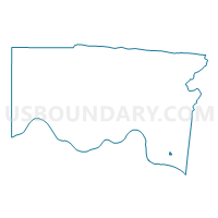
Voting District ANDERSON Z, Hamilton County, Ohio
About
Outline

Summary
| Unique Area Identifier | 647033 |
| Name | Voting District ANDERSON Z |
| County | Hamilton County |
| State | Ohio |
| Area (square miles) | 0.08 |
| Land Area (square miles) | 0.08 |
| Water Area (square miles) | 0.00 |
| % of Land Area | 100.00 |
| % of Water Area | 0.00 |
| Latitude of the Internal Point | 39.06842770 |
| Longtitude of the Internal Point | -84.36378010 |
Maps

Graphs
Select a template below for downloading or customizing gragh for Voting District ANDERSON Z, Hamilton County, Ohio


Neighbors
Neighoring Voting District (by Name) Neighboring Voting District on the Map
- Voting District ANDERSON J, Hamilton County, OH
- Voting District ANDERSON O, Hamilton County, OH
- Voting District ANDERSON R, Hamilton County, OH
- Voting District ANDERSON W, Hamilton County, OH